|
Case Study 5: Overview,
Introduction, and Getting Started - Printable
|
Home >
Overview - Page 1 of 1 Overview
 Printable
Overview, Introduction, and Getting Started Printable
Overview, Introduction, and Getting Started
Krome Avenue is a 33-mile, north-south route that bypasses Miami, Florida, on
the west side. It is essentially a rural route that has very little roadside
development. Florida’s Turnpike is about 5 miles to the east, providing
several east-west connections to Krome Avenue. Its two-lane configuration
has limited capacity compared to other facilities such as freeways and
multilane roadways. Most of the route now operates well within its capacity,
except that some congestion has been observed at critical locations. This is
a region of high population growth that is expected to generate continually
increasing traffic volumes. Prompted primarily by safety considerations, the
posted speeds have already been reduced below the 55 mph level typically
found on open highways.
In this case study, identify the goals,
objectives and analysis tools for an investigation of the existing level of
service on the entire route. We will then apply the analysis tools to assess
the current performance of this route and identify areas that are
deficient. Then, applying the same analysis tools, we will investigate some
alternatives for mitigating the deficiencies.
The main purpose of the case study is to illustrate the concepts and
practice of applying the transportation analysis tools in general and the Highway Capacity
Manual (HCM) in particular. Much of the discussion will be based on a
recently completed study of Krome Avenue that had similar goals and
objectives. Several problems will be presented to illustrate the application
of the tools and the interpretation of the results.
Krome Avenue is an
actual highway and the data used in the problems represent actual field data.
In some cases the alternative intersection improvements discussed in this
case study were chosen for their illustrative value and do not necessarily
reflect the recommendations of the original study.
[ Back ] to
HCMAG Home [ Continue
] to Introduction |
Page Break
[Introduction/intro1.htm]
Page Break
[Introduction/intro2.htm]
Page Break
[Introduction/intro3.htm]
Page Break
|
|
 |
|
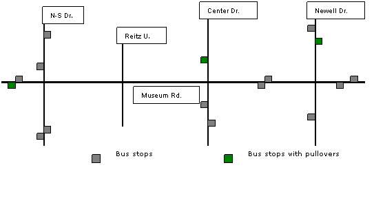
Figure 4. Locations of bus stops and
bus pullovers |
|
|
|
 |
|
Figure 5. Location of Crosswalks and
Adjacent Parking Facilities |
|
Page Break
[Introduction/intro4.htm]
Page Break
|
Home >
Getting Started - Page 1 of 7
Getting Started
 Printable Overview, Introduction, and Getting Started
Several issues will be considered as we begin this case
study, including the scope of the analysis, the stakeholders and their
perspectives, the overall goals for the analyses, the performance measures
to be used to quantify results for comparison, the tools to be used in
performing the analyses, the data requirements of these tools, and the
technical details that arise from using the HCM methods in this case study.
Scope of the Analysis
The
intersections along this section of Museum Road provide unique
characteristics that lend themselves to a variety of analysis techniques.
The Museum Road facility itself presents some special considerations that
must be taken into account in all analyses, due principally to the close
intersection spacing and the significant amounts of pedestrian, bicycle, and
bus activity.
Exhibit 5-7. Museum Road
Facilities for Analysis
|
|
Name |
Facility Type |
Existing Control |
Case Study
Interest |
|
Museum
Road |
Signalized Urban
Street |
-
Signals/TWSC
-
No
coordination
|
|
|
North-South
Drive |
Signalized
Intersection |
|
|
|
Reitz Union
Drive |
Unsignalized
Intersection |
|
-
Demand is expected to exceed capacity
-
Signalization will be difficult because of geometrics and proximity to
N-S Drive
-
Heavy
LT volume into new facility
-
One
leg has insignificant traffic
-
Signalization will require geometric modifications
|
|
Center
Drive |
Signalized
Intersection |
|
-
Unusual approach configuration, including one-way approaches
-
One
approach is a staging area for buses
|
|
Newell
Drive |
Signalized
Intersection |
|
-
Request for additional LT protection
-
Request for exclusive pedestrian phase(s)
-
Lower
vehicular volume permits consideration of double cycling as a means of
improving left-turn capacity and pedestrian quality of service
|
[
Back ] to Introduction [
Continue ] with Getting Started |
Page Break
Home >
Getting Started - Page 2 of 7
Getting Started
Stakeholders
There are several
stakeholder perspectives involved in the analysis and decisions affecting
Museum Road, including:
-
University of Florida administration must make critical decisions with
regard to any mitigating work to be done as a result of the new parking
structure. They have to weigh this situation with a multitude of others
from budget and resource perspectives to establish this among their
priorities and constraints.
-
Pedestrian-bicycle advocates have already succeeded in getting other
campus streets closed to vehicular traffic. This group will continue to
raise the awareness of the pedestrian and bicyclist to ensure they are
considered when making plans and decisions that focus on vehicular
efficiency, as well as keeping safety in the forefront of these
deliberations.
-
Public transit interests in the community are very strong and extend into
the bus activity within the campus. Ridership among students and
university employees (who ride free) is very high, with many depending
on this mode to get them to and from class and work.
-
Students and employees as motorists need mobility and access to campus
facilities and parking. Although parking is very limited on campus, what
is in place is virtually always at capacity, requiring a roadway network
to accommodate this (mostly employee) traffic affecting Museum Road.
-
Campus police have continuing concerns about enforcement of pedestrian
rights and obligations, which include uncontrolled pedestrian activity
between intersections, outside of crosswalks, and even against pedestrian
control.
[
Back ] [
Continue ] to
Getting Started |
Page Break
|
Home > Getting Started - Page 3 of 7 Getting
Started
Goals and Objectives
The driving force
behind this study is to provide sufficient information, detailed analyses,
and quantitative results to those responsible for deciding the best solution
to mitigate the impacts of this new parking structure on Museum Road.
Developing alternatives analyses using the HCM to compute performance
measures such as capacity, delay, queuing effects, etc., will assist them
in making decisions on intersection control, signal timing and coordination,
lane configuration improvements, and pedestrian, bicycle and transit
operations and safety.
We should also
point out that the
Manual on Uniform Traffic Control Devices (MUTCD) is
commonly used to determine if a signal is warranted, and in most
jurisdictions is the legal document used to determine many of the
characteristics of a design. However, it is also useful to compare the
forecasted operations of an intersection under different control scenarios.
The Highway Capacity Manual provides the tools for such an operational
analysis.
[
Back ] [ Continue ] with
Getting Started |
Page Break
|
Home > Getting Started - Page 4 of 7 Getting
Started
Performance Measures
The Highway Capacity
Manual provides several performance measures for intersections, both
signalized and unsignalized. For both types of intersections, the primary
measure of effectiveness is
control delay. Control delay is directly related to level of service
(LOS), a range of levels that categorize performance from the point of view
of the driver, or the user of the highway system. Level of service (along
with
v/c
ratio,
queue length, and other performance measures) will be used to help
determine if the intersection of Museum Road and Reitz Union Drive should be
changed from stop sign control to signal control.
Analyses
We must complete
several computations to gather the required information on the
performance of Museum Road under both stop sign and signal control. For
convenience, we've divided the analyses into two problems. We will consider
each problem separately. We will also see that each problem consists of
several separate computations, using the HCM or other tools, such as
macroscopic and microscopic simulation programs.
The following set of
case study problems will be analyzed:
|
Problem 1: |
This problem will review the results of the existing and projected
operations analysis for the Reitz Union Drive intersection to
determine possible mitigation alternatives, including investigating
pedestrian effects, alternate pedestrian crossings, installing a
signal, closing an approach, and analyzing turn lane treatments. |
|
Problem 2: |
This problem
will review the results of projected operations analysis for the Reitz
Union Drive intersection under signal control to analyze alternative
treatments, including phasing and timing, double cycles, an exclusive
pedestrian phase, and the effects of actuated versus coordinated
timing. |
[
Back ] [ Continue
] with Getting Started |
Page Break
|
Home > Getting Started - Page 5 of 7
Getting Started
Tools
Most of the
computations that we conduct in this case study will be with the
Highway
Capacity Manual, particularly those chapters that deal with intersection. This includes Chapter 16
(Signalized Intersections), and Chapter 17 (Unsignalized Intersections).
For some parts of
the analyses, however, and for certain traffic conditions, we might also consider
the use of other tools. There is a variety of software tools available that
we could use, including macroscopic flow models that
consider the progression of traffic platoons from one intersection to the
next, and microscopic traffic models that consider both the movement of
individual vehicles along an arterial and the details of actuated traffic
controller operations.
[
Back ] [ Continue ] with
Getting Started |
Page Break
|
Home > Getting Started - Page 6 of 7 Getting
Started
Data
Three kinds of data
are generally needed for traffic analysis. Demand or volume information
specifies the turning movement flows (usually in vehicles per hour) at each
intersection approach. Intersection geometry includes the number and
configuration of lanes at an intersection and along an arterial. Control
conditions include information about the traffic signal system, including
signal timing and phasing data. For this particular case study, pedestrian,
bicycle, transit, and intersection spacing and queuing data are also very
important.
|
Exhibit 5-8. Peak-Hour Turning
Movement Demand. |
|
Existing PM
Peak-Hour Volumes |
|
|
EB |
WB |
NB |
SB |
|
L |
T |
R |
P |
L |
T |
R |
P |
L |
T |
R |
P |
L |
T |
R |
P |
|
N-S |
57 |
295 |
57 |
165 |
126 |
303 |
189 |
105 |
50 |
424 |
268 |
225 |
126 |
194 |
64 |
25 |
|
Reitz |
111 |
650 |
2 |
250 |
0 |
580 |
52 |
250 |
12 |
0 |
8 |
150 |
60 |
0 |
144 |
250 |
|
Center |
|
531 |
35 |
|
58 |
360 |
|
|
106 |
|
188 |
|
35 |
39 |
87 |
|
|
Newell |
278 |
479 |
16 |
240 |
52 |
301 |
165 |
250 |
78 |
193 |
90 |
30 |
61 |
84 |
67 |
10 |
|
Future PM Peak-Hour
Volumes |
|
|
EB |
WB |
NB |
SB |
|
L |
T |
R |
P |
L |
T |
R |
P |
L |
T |
R |
P |
L |
T |
R |
P |
|
N-S |
59 |
458 |
59 |
|
198 |
477 |
298 |
|
52 |
437 |
416 |
|
126 |
200 |
66 |
|
|
Reitz |
379 |
670 |
2 |
250 |
0 |
597 |
178 |
250 |
12 |
0 |
8 |
150 |
204 |
0 |
484 |
250 |
|
Center |
|
680 |
44 |
|
60 |
468 |
|
|
137 |
|
194 |
|
36 |
40 |
90 |
|
|
Newell |
334 |
576 |
20 |
|
54 |
382 |
170 |
|
99 |
199 |
93 |
|
63 |
87 |
85 |
|
[
Back ] [ Continue ] with
Getting Started |
Page Break
|
Home > Getting Started - Page 7 of 7 Getting
Started
Technical Issues
The computational
procedures of the Highway Capacity Manual are complex, often including a
number of default values or assumptions that need to be understood (and
sometimes modified) if the procedures are to be applied correctly to
specific problems.
This case study
presents, and hopefully clarifies, a number of technical issues that often
arise in the application of Chapters 16 and 17 of the HCM. The Exhibit 5-9 lists these issues and identifies which are covered in each of the
problems presented as part of this case study.
|
Technical issue |
Problem in which the issue is covered |
|
Pedestrian
blockage
Queue lengths
Signal vs. TWSC
delay comparison
Actuated signal
control
Pedestrian and
bicycle influences
Exclusive turns
lanes
T-intersection
Minimum pedestrian green
Exclusive pedestrian phase
Adding signal phases
Phase overlapping
Unit extension and k-value
Arrival type and progression factor
Double cycle options |
1a. TWSC,
existing
1a. TWSC,
existing
1b. TWSC,
existing
1b. Signal,
existing
1b. Signal,
existing
1c. Signal,
improved geometry, future
1c. Signal,
improved geometry, future
2a. Signal,
future
2a. Signal,
future
2b. Signal,
future
2b. Signal,
future
2c. Signal,
future
2c. Signal,
future
2c. Signal,
future |
[
Back ] [
Continue ] to
Problem 1 |
|