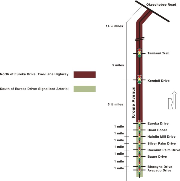
Problem 1: Determination of Facility Types for Analysis There are ten signalized intersections along the 33-mile section of Krome Avenue shown in Exhibit 3-2. Exclusive left-turn lanes are provided at each signalized intersection in both the northbound and southbound directions, except at Avocado Drive and at Tamiami Trail. The spacing between signals varies significantly throughout the route, starting at greater than ten miles in the north end and decreasing steadily to about one mile at the south end. So we are clearly dealing with a two-lane rural roadway at the north end and a signalized arterial at the south end. This suggests that at least two separate facilities must be identified for analysis purposes, because different HCM procedures apply to signalized arterials and two lane rural roads. There are three sub-problems to be considered here, each of which asks a specific question: Sub-problem 1a: At what point does Krome Avenue change from a two-lane highway to a signalized arterial? Sub-problem 1b: What Class should be assigned to each of the facilities that are identified? Sub-problem 1c: What, if any, conditions exist at the controlled intersections that could impact the analyses? Each of these sub-problems will be discussed separately in this problem. Before beginning the analysis of Krome Avenue, make sure you understand the following key issues:
Discussion: |
Page Break
Sub-problem 1a: Determining the Facility Type and Scope of the Analysis Step 1. Setup There are various methodologies that may be used to analyze traffic operations along Krome Avenue. We know that the intersection spacing varies between one and ten miles along Krome Avenue, with the intersection spacing decreasing as we proceed further south. To properly analyze the corridor, we will have to identify the type of facility that Krome Avenue belongs to. Given this information, at what point does Krome Avenue change from a two-lane highway to a signalized arterial? Consider:
Discussion: |
Page Break
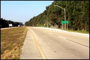
Sub-problem 1a: Determining the Facility Type and Scope of the Analysis Step 2: Results What are the primary criteria used to determine the facility type? The primary criterion the HCM uses for distinguishing an urban street vs. a two-lane highway is signalized intersection spacing. The HCM suggests in Chapter 20 that: Two-lane highways in urban and suburban areas with multiple signalized intersections at spacings of 2.0 mi or less can be evaluated with the methodology of Chapter 15, Urban Streets. The route overview shown in Exhibit 3-2 suggests that this question can be answered easily. The signals south of Eureka Drive have a consistent spacing of about 1 mile over this seven-mile section. There are only two signals in the 26 miles north of Eureka Drive. So, for purposes of analysis by the HCM procedures, Eureka Drive should clearly be the dividing point between the two-lane highway and the signalized arterial as shown in Exhibit 3-7. South of Eureka Drive: signalized arterial North of Eureka Drive: two-lane highway How might the facility designation matter in the analysis? The importance of the designation of Krome Avenue relates back to the stakeholders considered at the onset of this Case Study. The interested parties have different perspectives, and our analysis must be sensitive to these considerations. While our designation of Krome Avenue may be appropriate under today's conditions, future development may result in significant changes that may require us to reconsider this designation. What additional information might be needed? In consideration of the long-term nature of these corridor issues, the following issues and information are necessary to address future year conditions and to refine the scope of the analysis:
|
Page Break
| Exhibit 3-7. Krome Avenue Facility Types |
 |
Page Break
Sub-problem 1b: Determining the Facility Class and Scope of the Analysis Step 1. Setup In the previous sub-problem, we decided that Krome Avenue will be analyzed as a two-lane highway north of Eureka and as a signalized arterial facility south of Eureka. Within these various facility types, the analysis procedures are further refined according to facility class. We will now consider the class of each facility. Here are some issues to consider as you proceed with this analysis of the existing intersection. Consider:
Discussion: |
Page Break
Sub-problem 1b: Determining the Facility Class and Scope of the Analysis Let's discuss each of these issues and how each affects the operational analysis that we are about to complete. Why is there a further distinction within facility types? This question must be addressed separately for the arterial and two-lane highway portions. We will begin with the arterial portion. The need for various class types is important, because it represents the driver's ability to travel at a desired speed while considering the various influences on the urban street. In the case of a Class IV facility, one might put less emphasis on arterial throughput and speed as compared to a Class I facility; thus the level of service standards might be different in each of these cases. The two-lane highway is typically within a much more rural environment; and the distinction separates roadways where drivers expect to travel at high speeds (Class I), as compared to those facilities that might provide more of a recreational function (Class II). What parameters contribute to the distinction? For urban streets (arterials), the parameters that contribute to the distinctions include the level of roadside development, posted speeds, cross section, pedestrian activity, signal spacing or any other characteristics that would suggest differences in motorist perception of the quality of service. It is these differences that contribute to the slight disparities in running time, which are used to provide an indication of travel speed.
For two-lane highways, it is primarily the length of the trip, or type of trip that offers the distinction between the class type.
Are the segments under consideration homogenous throughout? In our case, the facility is approximately seven miles long with nearly equal signal spacing and no discernible differences in any of the other characteristics that would influence motorist expectations. Therefore no reasons can be offered for creating more than one facility for analysis purposes. So the only question that remains is, what class should be assigned to this facility? We have four classes from which to choose:
Discussion: |
Page Break
Sub-problem 1b: Determining the Facility Class and Scope of the Analysis Step 2. Results
Arterial Street Class
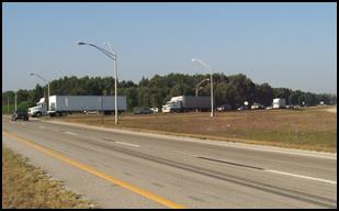
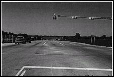
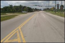
The preponderance of evidence above points to the designation of this facility as a Class I arterial. This choice is reinforced by the photographs that compare the HCM depiction of a typical Class I arterial in Exhibit 3-8 with a typical view of this section of Krome Avenue in Exhibit 3-9.
|
Page Break
Sub-problem 1b: Determining the Facility Class and Scope of the Analysis
Two-lane Highway Class The class structure for two-lane highways differs from that of signalized arterials. There are only two classes for two-lane highways:
The Class II category was created to avoid assigning an unacceptable level of service to a facility whose average speed has fallen below the normal expectation for high speed highways for reasons other than heavy traffic volumes. The HCM does not provide quantitative guidance for distinguishing between the two classes. The determination of the highway class is related more to the general nature of the highway and motorist expectations rather than quantitative field data. The posted speed on Krome Avenue is less than the default 55 mph for high speed rural highways. The section north of Kendall has a posted speed of 50 mph and the section south of Kendall has a posted speed of 45 mph. Both have very little roadside development, but the section south of Kendall has slightly more development than the section to the north. Because of the lower speed limit and increased development, it might be advisable to consider the south section as a Class II facility. In the absence of quantitative guidelines, we will perform the LOS estimation using both classes for this section. |
Page Break
Sub-problem 1b: Determining the Facility Class and Scope of the Analysis To summarize the discussion in this problem, Exhibit 3-10 describes the three facilities that will be analyzed in subsequent problems of this case study. The three facilities will be known as the north, center, and south sections, respectively.
Summary Discussion |
||||||||||||||||||||||
Page Break
Sub-problem 1c: Special Considerations for the Analysis Step 1. Setup The HCM procedures for LOS estimation on two-lane highways and signalized arterials assume no unusual conditions exist that: 1) could affect the outcome of the analysis beyond the scope of the procedures; or 2) would require some modification of the procedures to achieve valid results. This problem considers some unusual conditions that could impact the analyses. Consider:
Discussion: |
Page Break
Sub-problem 1c: Special Considerations for the Analysis There are many conditions that may affect the analysis of these types of facilities. Examples of such conditions include:
It is important therefore to examine all points in a facility to identify any abnormal conditions that could affect the procedures or the results. A specific condition could require a modification in the way a procedure is implemented to achieve more valid results. Another approach is to make a simplifying assumption in order to proceed with the analysis, followed by some post processing of the results for reasonableness. In some cases, especially those in which the demand volumes exceed the capacity, it could be preferable to eliminate the condition by, for example, assuming an improvement that increases the capacity. The objective of this sub-problem is simply to identify such conditions and not to prescribe the measures by which they should be accommodated. The accommodation of abnormal conditions will be dealt with under the site-specific sub-problems to be presented later. |
Page Break
Sub-problem 1c: Special Considerations for the Analysis Step 2. Results A detailed look at the three facilities defined on Krome Avenue has revealed very few abnormal conditions that would require special treatment. Those conditions that were identified as unusual include:
There are no conditions present that would suggest the need to use traffic models that are more complex than the HCM. For the unsignalized intersection at Okeechobee Road, the only such models that could be applied to this case study are those that estimate delays at a roundabout. We will examine the alternative of using a roundabout at Okeechobee Road in connection with Problem 4. The treatment of roundabouts as unsignalized intersections is limited (in the HCM 2000) to the estimation of capacity for single lane roundabouts. The investigation of a roundabout at that location will stay within the scope of the HCM.
|