Overview
This case study presents information on a decision that will be made by the Idaho Transportation Department regarding the operation of an intersection on U.S. Highway 95 within the City of Moscow, Idaho. The intersection is currently stop-sign controlled but consideration is being given to installing a traffic signal at the intersection. Click here to see what kinds of problems will be considered as part of this case study. The case study includes six problems, each one illustrating some aspect of this decision:
The purpose of each of the problems is to show how various traffic analysis tools that are contained in the Highway Capacity Manual can be applied to assist traffic analysts, engineers, planners and decision-makers in making sound investment decisions regarding the signalization decision. There are some situations where this amount of analysis would not be necessary in order to make an informed decision, but the issues presented herein should always be considered so as to assure the final decision is consistent with system performance objectives. The problems in this case study focus on the chapters of the HCM that deal with interrupted flow facilities, either signalized or unsignalized intersections. After studying this material, you should be able to:
|
Page Break
Introduction |
||||
|
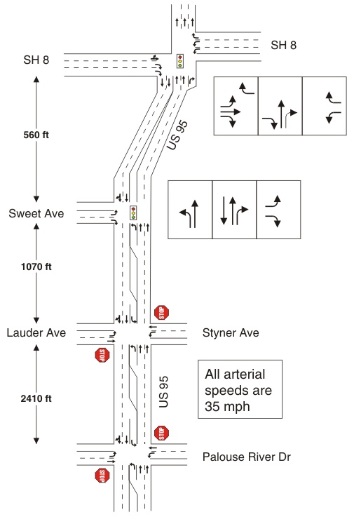
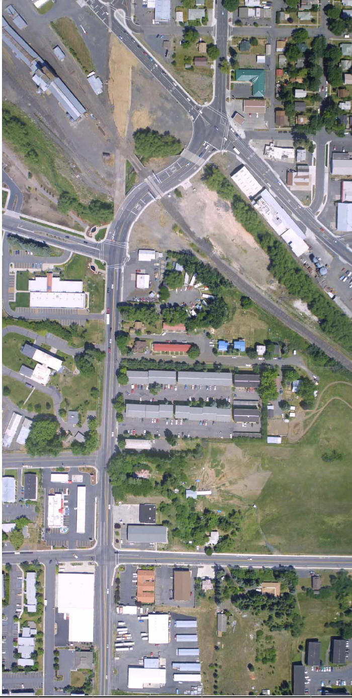
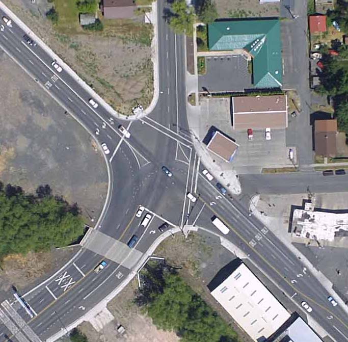
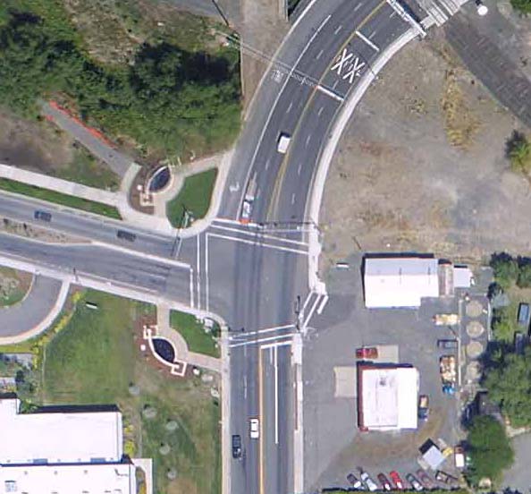
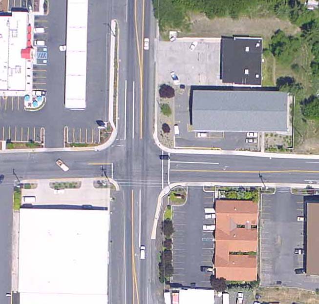
The intersection of U.S. 95 with Styner Avenue-Lauder Avenue is currently stop-controlled, and is the focus of a controversy over whether a signal ought to be installed. To understand the context in which our analyses will be conducted, it is important to note that U.S. 95 is the primary north-south state highway in Idaho, carrying between 15,000 and 23,000 vehicles per day through the city of Moscow, a community of 21,000 persons located in north Idaho. The city is home to the University of Idaho, the state's land grant university with a student population of nearly 11,000. Traffic on this section of U.S. 95 has been increasing at the rate of nearly two percent per year over the past decade. As it enters the city from the south, U.S. 95 transitions from a two-lane highway to an urban arterial with both signal and stop-sign control. Much of the land use to the south is farming, with some industrial, commercial, and residential development encroaching into these less developed sections of the area. The area to the east of U.S. 95 in the southern part of the city is primarily residential, particularly along Styner Avenue and Palouse River Drive. Click the link to Exhibit 1-1 on the left to see this section of the city's highway system. In the southern part of the city, U.S. 95 transitions from a two-lane highway to a four-lane arterial. Two of the intersections (State Highway 8 and Sweet Avenue) are controlled by traffic signals while three of the intersections (Taylor Avenue, Styner Avenue, and Palouse River Drive) are controlled by stop signs. There are also a number of driveway access points along the arterial. Click on Exhibit 1-2 to see an overview sketch of the U.S. 95 corridor and Exhibit 1-3 to see an aerial view of U.S. 95. The intersections of U.S. 95/State Highway 8 (see Exhibit 1-4) and U.S. 95/Sweet Avenue (see Exhibit 1-5) are signal controlled, operating fully-actuated, with no coordination between them. The three unsignalized intersections are located at Taylor Avenue/U.S. 95, Styner-Lauder Avenue/U.S. 95 (see Exhibit 1-6) and Palouse River Drive/U.S. 95. Click the links to the left to view aerial photographs of these intersections. |
||||
| Exhibit 1-2. Sketch overview of U.S. 95 corridor | Exhibit 1-3. Aerial photograph of U.S. 95 corridor | |||
|
Exhibit 1-5.
U.S. 95/ Sweet Avenue |
Exhibit 1-6.
U.S. 95/ Styner Avenue/ Lauder Avenue |
|||
Page Break
|
Exhibit 1-1. Sketch overview of Moscow highway system The U.S. 95 corridor in the city of Moscow is shown in the figure below. The corridor runs from State Highway 8 on the north to Palouse River Drive on the south. Two signalized intersections and two two-way stop-controlled intersections are located on this section of the U.S. 95 corridor. The corridor extends south of the city and transitions into a multilane highway and then a two lane rural highway. State Highway 8 is an east-west highway through the city. In the section shown below, it is two lanes, one in each direction. Two signalized intersections and two TWSC intersections are located on this section of the highway. Note: You can see aerial photographs of several of the U.S. 95 intersections by moving the mouse over the intersections and clicking on them. |
|
|
Page Break
Page Break
|
Exhibit 1-3. Aerial photograph of U.S. 95 corridor in Moscow The aerial photograph shows the U.S. 95 corridor as it runs north-south in the City of Moscow from the State Highway 8 intersection on the north to the Styner Avenue/Lauder Avenue intersection on the south. Move the cursor over the photograph to zoom in on the intersections of State Highway 8, Sweet Avenue, and Styner Avenue/Lauder Avenue. |
|
|
Page Break
|
Exhibit 1-4. Aerial photograph of U.S. 95/State Highway 8 The intersection of U.S. 95 and State Highway 8 is located at the southern end of Moscow's central business district. U.S. 95 continues to the north as the northern portion of the downtown's one-way couplet. The southern portion of the couplet is the eastbound approach to this intersection. The eastbound approach serves traffic coming from Moscow's east side and smaller communities such as Troy and Deary to the east.
|
Page Break
|
Exhibit 1-5. Aerial photograph of U.S. 95/Sweet Ave The intersection of U.S. 95 and Sweet Avenue is a signalized T intersection. The eastbound Sweet Avenue approach serves as the south entrance to the University of Idaho. It is a four lane boulevard with a median strip. U.S. 95 is has turning lanes from the north and south to serve university traffic. The intersection actually functions as a four leg intersection with access provided to a business located on the westbound approach to the intersection but traffic volumes on this approach are so minimal that they can be ignored.
|
Page Break
|
Exhibit 1-6. Aerial Photograph of the Intersection of U.S. 95 with Styner Ave/Lauder Ave The intersection of U.S. 95/Styner Avenue/Lauder Avenue is a four leg TWSC intersection. The westbound approach, Styner Avenue, serves a growing residential area in the eastern section of the city. Lauder Avenue serves as a minor entrance to the University of Idaho and access to student and faculty residences. A gas station/mini-mart is located on the northwest quadrant of the intersection. Other auto-oriented businesses are located on the other quadrants. Note: You can see other views of the intersection approach by moving your mouse to the approach and clicking on the approach.
|
Page Break
 |
Page Break
Introduction City residents have asserted that increasing traffic volumes at the intersection of Styner Avenue, Lauder Avenue, and U.S. 95 are increasing delays for and reducing the safety of motorists traveling through the intersection. Traffic on Styner and Lauder, the minor streets of this two-way stop-controlled intersection, is controlled by stop signs. Limited sight distance for drivers on Styner and Lauder contributes to the safety problem. As a result of these citizen complaints, the city has requested that the Idaho Transportation Department signalize the intersection. Discussion: |
Page Break
Getting Started
As we begin this case study, we will consider several issues, including the scope of the analysis that we will undertake, the stakeholders and the issues that are important to them, the goal of the case study, the performance measures that we will use to support this decision-making process, the analyses that we will perform to generate our performance measures, the tools that we will use, the data that is required, and some of the technical issues with respect to the Highway Capacity Manual that are included in each problem. Click here to see what kinds of problems will be considered as part of this case study. Scope of the Analysis We will also consider travel patterns that normally occur during a typical weekday, while the University of Idaho is in session. Traffic volumes vary throughout this typical weekday, with peak periods occurring during the morning and afternoon, with a secondary peak during the midday. There are also mini-peak periods during class change times, but these variations are not significant enough to consider for our analysis here. We'll see later in the analysis, however, that there are other time periods, such as during special university events, that traffic volumes increase significantly and have a bearing on the results that we need to consider. While many people are concerned about the operation of the intersection today, it is also important to consider how the intersection is likely to operate in the future. The investment in signal controllers and related equipment is sizable, and its feasibility must be justified by looking at both conditions present today and those likely to exist in the future. For this reason, we will also consider future traffic volume projections for the U.S. 95 corridor. |
Page Break
Getting Started Stakeholders In addition, residents of the city will need to understand the rationale for any final decision that is made regarding the intersection and whether a signal should be installed or not. This points up an important issue in any technical analysis. While any analysis must be technically sound and based on standard methods of professional practice, it must also be presented in such a way that it is understandable by decision makers and elected officials (who often do not have technical backgrounds) as well as the general public. This is particularly important as we consider such concepts as level of service, and as we talk about sensitivity analysis and the relative certainty that we have in our final results.
Goals We should also point out that the Manual on Uniform Traffic Control Devices (MUTCD) is commonly used to determine if a signal is warranted and in most jurisdictions is the legal document used to determine many of the characteristics of a design. However, it is also useful to compare the forecasted operations of an intersection under different control scenarios. The Highway Capacity Manual provides the tools for such an operational analysis. with Getting Started |
Page Break
Getting Started
Performance Measures We will also need to consider other performance measures besides just level of service in order to fully judge the overall performance characteristics of the intersection. Depending on the type of control at the intersection, these may include the volume/capacity ratio of the critical movements at the intersection, the traffic signal cycle length, and/or queue length considerations. Analyses
with Getting Started |
Page Break
Getting Started Tools For some parts of the analyses, however, and for certain traffic conditions, we will consider the use of other tools. There are a variety of software tools available that we could use, and for illustrative purposes we will demonstrate the use of only two, TRANSYT 7F and CORSIM. TRANSYT 7F is a macroscopic flow model that consider the progression of traffic platoons from one intersection to the next. CORSIM is a microscopic traffic model that considers the movement of individual vehicles along an arterial and the details of actuated traffic controller operations. Other software packages could also be applied with equal effectiveness. Data The data for each problem can be found at the links provided below. These links are also provided in each of the problems, as you need to access them.
U.S. 95/Styner Avenue/Lauder Avenue with Getting Started |
Page Break
Getting Started Technical Issues This case study presents, and hopefully clarifies, a number of technical issues that often arise in the application of chapters 15, 16, and 17 of the HCM. A searchable index of the issues and important key words addressed in this and other case studies within the HCMAG is provided near the bottom of the table of contents located in the left margin of this page and labeled as "Search". to Problem 1 |


